GTA 6 Map — Mount Kalaga National Park
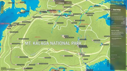
Mount Kalaga National Park is the least mapped region on the GTA 6 map, and the numbers are worth stating plainly: 4 records, 0 with coordinates, 2 with a confirmed name. Nothing in this region can be drawn on the map yet.
Mount Kalaga in numbers
| Measure | Count | Share of region |
|---|---|---|
| Records assigned to the park | 4 | 100% |
| Records with in-game coordinates | 0 | 0% |
| Records with a named in-game address | 2 | 50% |
| Records with no coordinate pair yet | 4 | 100% |
| Share of the atlas's 3,431 records | 4 | 0.1% |
Counts come from the atlas region snapshot of 17 November 2026, pinned to GTADB revision 5c1d69f.
The four records, one by one
Four is few enough to list in full, with exactly what the source says about each:
| Record | Address as written in the source | Tags | Name evidence | Placement |
|---|---|---|---|---|
| L1207 | Fire Danger Sign, Mount Kalaga National Park |
landmark | KNOWN (SUPPORTED) | UNPOSITIONED |
| L1027 | Cabin, Mount Kalaga National Park |
unconfirmed | KNOWN (SUPPORTED) | UNPOSITIONED |
| L822 | USCAS?, Mount Kalaga National Park |
demolished | UNKNOWN | UNPOSITIONED |
| L1028 | ?, Mount Kalaga National Park |
none | UNKNOWN | UNPOSITIONED |
Two of the four carry names this site will let you search: Fire Danger Sign and Cabin. Both have KNOWN name evidence and a SUPPORTED record status, which is why they count as named even though neither can be placed.
USCAS? is the awkward one. It contains a question mark, so by the dataset's own rule it is not a confirmed name — we reproduce the string exactly as written rather than tidying it into a plausible place name. It also carries a demolished flag, which in this dataset means the record was marked as removed at some point; we do not know when or why.
The fourth record has no name at all: its address is a single question mark.
What zero coordinates means in practice
All four records are marked UNPOSITIONED in the source evidence, and none carries a coordinate pair. That has two consequences that pull in opposite directions.
The search works, the map does not. Both named records can be found through the atlas search — the name and the region are there. What is missing is the position, so no marker appears when you filter the map to Mount Kalaga National Park. The atlas shows an empty region rather than a guessed one.
Nothing is faked to fill the gap. The alternative would be to drop four markers somewhere inside an approximate park boundary and call it coverage. That is the approach this atlas deliberately does not take: an empty map is more useful than a wrong one.
Why the park is empty
All four records come from a single source label, Mount Kalaga National Park. Every other region in the atlas has at least two positioned records; the park has none, which puts it at the opposite end of the dataset from Vice City (2,117 records, 2,091 positioned).
This is a limit of the pre-release community reconstruction, not a statement about the game. GTA 6 launches on 19 November 2026, and coverage in regions like this one is what the community will fill in first once the game is in hand.
A national park is an odd region to map
It is also the hardest kind of region to confirm before release: records inland and away from roads have no signage to read and no address to copy. The four records that do exist are exactly what you would expect from that — a fire danger sign, a cabin, and two entries nobody could name.
The park's real value on this site comes later — it is one of six region pages, and it gives the map a complete set of URLs for the six regions of Leonida rather than only the four that have real data behind them.
Common questions
Is there any way to see these places?
Yes — search the name in the atlas and you get the record with its region. You just will not get a marker, because the source data for the park has no coordinate pairs.
What are the four Mount Kalaga records?
A fire danger sign, a cabin (both named and SUPPORTED), a record written USCAS? and flagged demolished, and one with no name at all. None of the four has a coordinate.
Will this region fill in?
The atlas tracks a pinned revision of GTADB. When the community places positions in the park, they arrive with the next update. Positions remain approximate even then, since the whole dataset is a reconstruction.
Is this an official map?
No. It is a community reconstruction under CC BY 4.0, not an official Rockstar map. For launch facts, see the release date page.
See these places on the map, search them, and save the ones you want.
Open the atlasMap data: GTADB / Map GTA community reconstruction · preferred source map.gtadb.org · licensed CC BY 4.0 · pinned revision 5c1d69ff864623d181da5457afaacd00b623e1a4 · transformed presentation · deterministic, pixel-aligned transform · community placement APPROXIMATE · approximate visualization scale · not an official Rockstar map. Per-region counts generated 17 November 2026 from the atlas region snapshot. Region totals exclude 755 records whose source label could not be matched to a region — see the all-regions overview for how the six numbers add up.