GTA 6 Map Regions
The GTA 6 map splits into six named regions: they carry 2,676 of the atlas's 3,431 place records, and the other 755 have no region label in the source data and are counted apart, so the six numbers below add up without inflating anything.
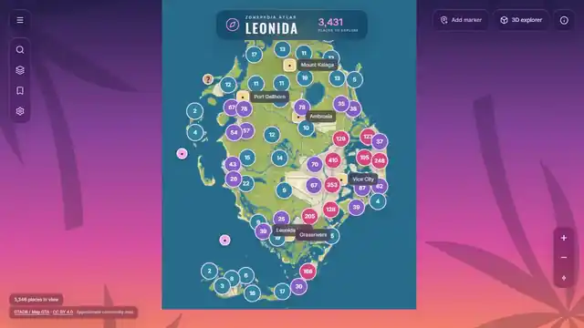
All six regions
- Vice City2,117 records · 2,091 with coordinates · 467 named
- Leonida Keys261 records · 256 with coordinates · 37 named
- Port Gellhorn196 records · 194 with coordinates · 69 named
- Ambrosia96 records · 90 with coordinates · 36 named
- Mount Kalaga4 records · 0 with coordinates · 2 named
- Grassrivers2 records · 2 with coordinates · 1 named
Looking for one place rather than a region? The locations index groups every record by region and by address label, and explains how the named ones are counted.
How the numbers add up
| Measure | Count |
|---|---|
| Place records in the atlas | 3,431 |
| Assigned to one of the six regions | 2,676 |
| No region label in the source data | 755 |
| Records that have a position on the map | 3,340 |
| Records with a named in-game address | 948 |
2,676 plus 755 is 3,431. That is the whole check: every record is either inside a region page or in the unassigned group, and nothing is counted twice. The same split holds for the other two measures — 2,633 positioned records sit in the six regions and 707 in the unassigned group, which is 3,340; 612 named records sit in the six regions and 336 in the unassigned group, which is 948.
What the 755 unassigned records are
They are not broken records. Each one carries a source label that has no explicit mapping to an atlas region, so the atlas leaves it out of the regional totals instead of guessing where it belongs. The largest groups are county-style labels, raceway and island labels, and the state name itself:
- Mariana County — 98 records, 90 with coordinates
- Kelly County — 79 records, all with coordinates, 43 named · every named place listed
- Capri — 74 records, all with coordinates
- Waning Sands — 65 records, 64 with coordinates
- Gellhorn International Raceway — 64 records, all with coordinates, 58 named
- Lummox County — 61 records, all with coordinates, 35 named
- Leonida — 59 records, 21 with coordinates (the label is the state, not a place) · what the state label means
- Vice-Dale County — 51 records, all with coordinates
- Leonard County — 37 records, 12 named, including Lake Leonida
None of those names appears on Rockstar's published region list. They are community labelling, and the Leonida page explains the difference between the six official names and the rest. Another 32 labels with fewer than ten records each account for the rest of the 755.
All 755 still appear on the map when you open the atlas: they are pinned, searchable and saveable like every other record. The only thing they lack is a region page to live on. When the source data gains a mapping for those labels, the regional totals will rise without the atlas total changing — the 3,431 stays 3,431.
Which region to open first
Vice City is about 62% of the atlas and the only region where the data is dense enough to be worth browsing a list. Leonida Keys and Port Gellhorn are the middle tier — a few hundred records each. Mount Kalaga (4 records, none with a coordinate) and Grassrivers (2 records) are honest placeholders: the regions exist in the game world, the community data for them barely does yet, and neither page pretends otherwise.
Every record on these pages is already on the map, searchable and saveable.
Open the atlasMap data: GTADB / Map GTA community reconstruction · preferred source map.gtadb.org · licensed CC BY 4.0 · pinned revision 5c1d69ff864623d181da5457afaacd00b623e1a4 · transformed presentation · deterministic, pixel-aligned transform · community placement APPROXIMATE · approximate visualization scale · not an official Rockstar map. Region counts generated 17 November 2026 from the atlas region snapshot at atlas.zonepedia.com/regions.json.